[转自 Flyingis]Geometry 对象浅析
作者:Flyingis
ArcEngine
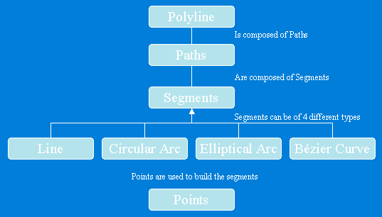
Geometry库定义了基本几何图形的矢量表达形式,顶级的几何图形有Points、Multipoints、Polylines、Polygons、Multipatches,Geodatabase和绘图系统使用这些几何图形来定义其他各种形状的特征和图形,提供了编辑图形的操作方法和地图符号系统符号化特征数据的途径。
Geometry库中几个核心类和接口构成了Geometry对象的基本框架。
GeometryEnvironment
GeometryEnvironment提供了从不同的输入、设置或获取全局变量来创建几何图形的方法,以便控制geometry方法的行为。GeometryEnvironment对象是一个单例对象。
 public IPolyline TestGeometryEnvironment()

 {
{ ISpatialReferenceFactory spatialReferenceFactory = new SpatialReferenceEnvironmentClass(); //Create a projected coordinate system and define its domain, resolution, and x,y tolerance. ISpatialReferenceResolution spatialReferenceResolution = spatialReferenceFactory.CreateProjectedCoordinateSystem((int)esriSRProjCSType.esriSRProjCS_NAD1983UTM_11N) as ISpatialReferenceResolution; spatialReferenceResolution.ConstructFromHorizon(); ISpatialReferenceTolerance spatialReferenceTolerance = spatialReferenceResolution as ISpatialReferenceTolerance; spatialReferenceTolerance.SetDefaultXYTolerance(); ISpatialReference spatialReference = spatialReferenceResolution as ISpatialReference; //Create an array of WKSPoint structures starting in the middle of the x,y domain of the //projected coordinate system. double xMin; double xMax; double yMin; double yMax; spatialReference.GetDomain(out xMin, out xMax, out yMin, out yMax); double xFactor = (xMin + xMax) * 0.5; double yFactor = (yMin + yMax) * 0.5; WKSPoint[] wksPoints = new WKSPoint[10]; for (int i = 0; i < wksPoints.Length; i++)
 { wksPoints[i].X = xFactor + i; wksPoints[i].Y = yFactor + i;
 } IPointCollection4 pointCollection = new PolylineClass(); IGeometryBridge2 geometryBridge = new GeometryEnvironmentClass(); geometryBridge.AddWKSPoints(pointCollection, ref wksPoints); IPolyline polyline = pointCollection as IPolyline; polyline.SpatialReference = spatialReference; return polyline;
 }
}
new
GeometryEnvironmentClass仅仅是创建了一个指向已存在的GeometryEnvironmentClass的引用。注意IGeometryBridge2接口的使用,addWKSPoints方法将WKSPoint二维点添加到PointCollection中,用于构建path、ring、polyline、polygon,或增加新点到Multipoint、TriangleFan、TriangleStrip。在Geometry库中,除了IGeometryBridge2还有IGeometryBridge接口,后者继承了前者,增加了一些编辑功能(添加点、插入点、重置点、分段等)。
GeometryBag
GeometryBag是支持IGeometry接口的几何对象引用的集合,任何几何对象都可以通过IGeometryCollection接口添加到GeometryBag中,但是在使用拓扑操作的时候,需要注意不同类型的几何类型可能会有相互不兼容的情况。在向GeometryBag中添加几何对象的时候,GeometryBag对象需要指定空间参考,添加到其中的几何对象均拥有和GeometryBag对象一样的空间参考。
private IPolygon GeometryBag_Example(IFeatureClass featureClass){ //Check input objects. if (featureClass == null) { return null; } IGeoDataset geoDataset = featureClass as IGeoDataset; ISpatialFilter queryFilter = new SpatialFilterClass(); //Set the properties of the spatial filter here. IGeometry geometryBag = new GeometryBagClass(); //Define the spatial reference of the bag before adding geometries to it. geometryBag.SpatialReference = geoDataset.SpatialReference; //Use a nonrecycling cursor so each returned geometry is a separate object. IFeatureCursor featureCursor = featureClass.Search(queryFilter, false); IGeometryCollection geometryCollection = geometryBag as IGeometryCollection; IFeature currentFeature = featureCursor.NextFeature(); while (currentFeature != null) { //Add a reference to this feature's geometry into the bag. //You don't specify the before or after geometry (missing), //so the currentFeature.Shape IGeometry is added to the end of the geometryCollection. object missing = Type.Missing; geometryCollection.AddGeometry(currentFeature.Shape, ref missing, ref missing); currentFeature = featureCursor.NextFeature(); } // Create the polygon that will be the union of the features returned from the search cursor. // The spatial reference of this feature does not need to be set ahead of time. The // ConstructUnion method defines the constructed polygon's spatial reference to be the same as // the input geometry bag. ITopologicalOperator unionedPolygon = new PolygonClass(); unionedPolygon.ConstructUnion(geometryBag as IEnumGeometry); return unionedPolygon as IPolygon;}
Points
一个点包括X、Y坐标,同时可以增加M、Z值及ID属性来扩展点的功能。
Multipoints
点的集合,多点组成Multipoint几何类型,使用multipoint对象实现了的IPointCollection接口可以访问所有的点元素,这些点同样可以拥有M、Z值及ID属性来获得更多的地理空间内涵。
下面列举一个例子,通过一个已知的polyline来定义一个新的multipart polyline。
public IPolyline ConstructMultiPartPolyline(IPolyline inputPolyline){ IGeometry outGeometry = new PolylineClass(); //Always associate new, top-level geometries with an appropriate spatial reference. outGeometry.SpatialReference = inputPolyline.SpatialReference; IGeometryCollection geometryCollection = outGeometry as IGeometryCollection; ISegmentCollection segmentCollection = inputPolyline as ISegmentCollection; //Iterate over existing polyline segments using a segment enumerator. IEnumSegment segments = segmentCollection.EnumSegments; ISegment currentSegment; int partIndex = 0;; int segmentIndex = 0;; segments.Next(out currentSegment,ref partIndex, ref segmentIndex); while(currentSegment != null) { ILine normal = new LineClass(); //Geometry methods with _Query_ in their name expect to modify existing geometries. //In this case, the QueryNormal method modifies an existing line //segment (normal) to be the normal vector to //currentSegment at the specified location along currentSegment. currentSegment.QueryNormal(esriSegmentExtension.esriNoExtension, 0.5, true, currentSegment.Length / 3, normal); //Since each normal vector is not connected to others, create a new path for each one. ISegmentCollection newPath = new PathClass(); object missing = Type.Missing; newPath.AddSegment(normal as ISegment, ref missing, ref missing); //The spatial reference associated with geometryCollection will be assigned to all incoming paths and segments. geometryCollection.AddGeometry(newPath as IGeometry, ref missing, ref missing); segments.Next(out currentSegment,ref partIndex, ref segmentIndex); } //The geometryCollection now contains the new, multipart polyline. return geometryCollection as IPolyline;}
ISegment接口的QueryNormal方法用来在弧段上的某一点生成该弧段的法线,指定其长度,这样就生成了新的segment,并且多个path添加到geometryCollection中,以IPolyline的形式返回。
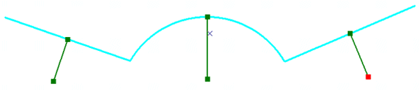
Polylines
Polylines是有序path组成的集合,可以拥有M、Z和ID属性值。Polyline对象的IPointCollection接口包含了所有节点的复制,IGeometryCollection接口可以获取polyline的paths,ISegmentCollection接口可以获取polyline的segments。
Polyline结构图
Polygons
Polygon是一系列rings组成的集合,可以拥有M、Z和ID属性值。每一个ring由一个或多个segment组成,Polygon或ring对象的IPointCollection接口包含了所有节点的复制,IGeometryCollection接口可以获取polygon的rings,ISegmentCollection接口可以获取polygon的segments。
Polygon结构图

Multipatch
Multipatch用于描述3D面状几何类型,由一系列的矢量三角形构成,如果其中的part是一个ring,那么它必须是封闭的,第一个节点和最后一个节点相同,另外每个part所包含节点的顺序非常重要,Inner
Rings在Outer Rings之后,代表单个表面patch的一系列rings必须由第一个ring开始。

在9.0以后的开发包中,使用IGeneralMultiPatchCreator创建新的Multipatch,IGeometryMaterial进行材质贴图。
public IMultiPatch CreateMultipatch(){ //Prepare the geometry material list. IGeometryMaterial texture = new GeometryMaterialClass(); texture.TextureImage = "C:\\Temp\\MyImage.bmp"; IGeometryMaterialList materialList = new GeometryMaterialListClass(); materialList.AddMaterial(texture); //Create the multipatch. IGeneralMultiPatchCreator multiPatchCreator = new GeneralMultiPatchCreatorClass(); multiPatchCreator.Init(4, 1, false, false, false, 4, materialList); //Set up part. //Could also use a Ring or a TriangleFan. multiPatchCreator.SetPatchType(0, esriPatchType.esriPatchTypeTriangleStrip); multiPatchCreator.SetMaterialIndex(0, 0); multiPatchCreator.SetPatchPointIndex(0, 0); multiPatchCreator.SetPatchTexturePointIndex(0, 0); //Set real-world points. WKSPointZ upperLeft = new WKSPointZ(); WKSPointZ lowerLeft = new WKSPointZ(); WKSPointZ upperRight = new WKSPointZ(); WKSPointZ lowerRight = new WKSPointZ(); upperLeft.X = 0; upperLeft.Y = 0; upperLeft.Z = 0; upperRight.X = 300; upperRight.Y = 0; upperRight.Z = 0; lowerLeft.X = 0; lowerLeft.Y = 0; lowerLeft.Z = -100; lowerRight.X = 300; lowerRight.Y = 1; lowerRight.Z = -100; multiPatchCreator.SetWKSPointZ(0, ref upperRight); multiPatchCreator.SetWKSPointZ(1, ref lowerRight); multiPatchCreator.SetWKSPointZ(2, ref upperLeft); multiPatchCreator.SetWKSPointZ(3, ref lowerLeft); //Set texture points. //Set the texture coordinates for a panel. WKSPoint textureUpperLeft = new WKSPoint(); WKSPoint textureLowerLeft = new WKSPoint(); WKSPoint textureUpperRight = new WKSPoint(); WKSPoint textureLowerRight = new WKSPoint(); textureUpperLeft.X = 0; textureUpperLeft.Y = 0; textureUpperRight.X = 1; textureUpperRight.Y = 0; textureLowerLeft.X = 0; textureLowerLeft.Y = 1; textureLowerRight.X = 1; textureLowerRight.Y = 1; multiPatchCreator.SetTextureWKSPoint(0, ref textureUpperRight); multiPatchCreator.SetTextureWKSPoint(1, ref textureLowerRight); multiPatchCreator.SetTextureWKSPoint(2, ref textureUpperLeft); multiPatchCreator.SetTextureWKSPoint(3, ref textureLowerLeft); IMultiPatch multiPatch = multiPatchCreator.CreateMultiPatch() as IMultiPatch; return multiPatch;}
参考资料:ArcEngine 9.2帮助文档 作者:Flyingis
ArcEngine
Geometry库定义了基本几何图形的矢量表达形式,顶级的几何图形有Points、Multipoints、Polylines、Polygons、Multipatches,Geodatabase和绘图系统使用这些几何图形来定义其他各种形状的特征和图形,提供了编辑图形的操作方法和地图符号系统符号化特征数据的途径。
Geometry库中几个核心类和接口构成了Geometry对象的基本框架。
GeometryEnvironment
GeometryEnvironment提供了从不同的输入、设置或获取全局变量来创建几何图形的方法,以便控制geometry方法的行为。GeometryEnvironment对象是一个单例对象。
public IPolyline TestGeometryEnvironment(){ ISpatialReferenceFactory spatialReferenceFactory = new SpatialReferenceEnvironmentClass(); //Create a projected coordinate system and define its domain, resolution, and x,y tolerance. ISpatialReferenceResolution spatialReferenceResolution = spatialReferenceFactory.CreateProjectedCoordinateSystem((int)esriSRProjCSType.esriSRProjCS_NAD1983UTM_11N) as ISpatialReferenceResolution; spatialReferenceResolution.ConstructFromHorizon(); ISpatialReferenceTolerance spatialReferenceTolerance = spatialReferenceResolution as ISpatialReferenceTolerance; spatialReferenceTolerance.SetDefaultXYTolerance(); ISpatialReference spatialReference = spatialReferenceResolution as ISpatialReference; //Create an array of WKSPoint structures starting in the middle of the x,y domain of the //projected coordinate system. double xMin; double xMax; double yMin; double yMax; spatialReference.GetDomain(out xMin, out xMax, out yMin, out yMax); double xFactor = (xMin + xMax) * 0.5; double yFactor = (yMin + yMax) * 0.5; WKSPoint[] wksPoints = new WKSPoint[10]; for (int i = 0; i < wksPoints.Length; i++) { wksPoints[i].X = xFactor + i; wksPoints[i].Y = yFactor + i; } IPointCollection4 pointCollection = new PolylineClass(); IGeometryBridge2 geometryBridge = new GeometryEnvironmentClass(); geometryBridge.AddWKSPoints(pointCollection, ref wksPoints); IPolyline polyline = pointCollection as IPolyline; polyline.SpatialReference = spatialReference; return polyline;}
new
GeometryEnvironmentClass仅仅是创建了一个指向已存在的GeometryEnvironmentClass的引用。注意IGeometryBridge2接口的使用,addWKSPoints方法将WKSPoint二维点添加到PointCollection中,用于构建path、ring、polyline、polygon,或增加新点到Multipoint、TriangleFan、TriangleStrip。在Geometry库中,除了IGeometryBridge2还有IGeometryBridge接口,后者继承了前者,增加了一些编辑功能(添加点、插入点、重置点、分段等)。
GeometryBag
GeometryBag是支持IGeometry接口的几何对象引用的集合,任何几何对象都可以通过IGeometryCollection接口添加到GeometryBag中,但是在使用拓扑操作的时候,需要注意不同类型的几何类型可能会有相互不兼容的情况。在向GeometryBag中添加几何对象的时候,GeometryBag对象需要指定空间参考,添加到其中的几何对象均拥有和GeometryBag对象一样的空间参考。
private IPolygon GeometryBag_Example(IFeatureClass featureClass){ //Check input objects. if (featureClass == null) { return null; } IGeoDataset geoDataset = featureClass as IGeoDataset; ISpatialFilter queryFilter = new SpatialFilterClass(); //Set the properties of the spatial filter here. IGeometry geometryBag = new GeometryBagClass(); //Define the spatial reference of the bag before adding geometries to it. geometryBag.SpatialReference = geoDataset.SpatialReference; //Use a nonrecycling cursor so each returned geometry is a separate object. IFeatureCursor featureCursor = featureClass.Search(queryFilter, false); IGeometryCollection geometryCollection = geometryBag as IGeometryCollection; IFeature currentFeature = featureCursor.NextFeature(); while (currentFeature != null) { //Add a reference to this feature's geometry into the bag. //You don't specify the before or after geometry (missing), //so the currentFeature.Shape IGeometry is added to the end of the geometryCollection. object missing = Type.Missing; geometryCollection.AddGeometry(currentFeature.Shape, ref missing, ref missing); currentFeature = featureCursor.NextFeature(); } // Create the polygon that will be the union of the features returned from the search cursor. // The spatial reference of this feature does not need to be set ahead of time. The // ConstructUnion method defines the constructed polygon's spatial reference to be the same as // the input geometry bag. ITopologicalOperator unionedPolygon = new PolygonClass(); unionedPolygon.ConstructUnion(geometryBag as IEnumGeometry); return unionedPolygon as IPolygon;}
Points
一个点包括X、Y坐标,同时可以增加M、Z值及ID属性来扩展点的功能。
Multipoints
点的集合,多点组成Multipoint几何类型,使用multipoint对象实现了的IPointCollection接口可以访问所有的点元素,这些点同样可以拥有M、Z值及ID属性来获得更多的地理空间内涵。
下面列举一个例子,通过一个已知的polyline来定义一个新的multipart polyline。
public IPolyline ConstructMultiPartPolyline(IPolyline inputPolyline){ IGeometry outGeometry = new PolylineClass(); //Always associate new, top-level geometries with an appropriate spatial reference. outGeometry.SpatialReference = inputPolyline.SpatialReference; IGeometryCollection geometryCollection = outGeometry as IGeometryCollection; ISegmentCollection segmentCollection = inputPolyline as ISegmentCollection; //Iterate over existing polyline segments using a segment enumerator. IEnumSegment segments = segmentCollection.EnumSegments; ISegment currentSegment; int partIndex = 0;; int segmentIndex = 0;; segments.Next(out currentSegment,ref partIndex, ref segmentIndex); while(currentSegment != null) { ILine normal = new LineClass(); //Geometry methods with _Query_ in their name expect to modify existing geometries. //In this case, the QueryNormal method modifies an existing line //segment (normal) to be the normal vector to //currentSegment at the specified location along currentSegment. currentSegment.QueryNormal(esriSegmentExtension.esriNoExtension, 0.5, true, currentSegment.Length / 3, normal); //Since each normal vector is not connected to others, create a new path for each one. ISegmentCollection newPath = new PathClass(); object missing = Type.Missing; newPath.AddSegment(normal as ISegment, ref missing, ref missing); //The spatial reference associated with geometryCollection will be assigned to all incoming paths and segments. geometryCollection.AddGeometry(newPath as IGeometry, ref missing, ref missing); segments.Next(out currentSegment,ref partIndex, ref segmentIndex); } //The geometryCollection now contains the new, multipart polyline. return geometryCollection as IPolyline;}
ISegment接口的QueryNormal方法用来在弧段上的某一点生成该弧段的法线,指定其长度,这样就生成了新的segment,并且多个path添加到geometryCollection中,以IPolyline的形式返回。
Polylines
Polylines是有序path组成的集合,可以拥有M、Z和ID属性值。Polyline对象的IPointCollection接口包含了所有节点的复制,IGeometryCollection接口可以获取polyline的paths,ISegmentCollection接口可以获取polyline的segments。
Polyline结构图
Polygons
Polygon是一系列rings组成的集合,可以拥有M、Z和ID属性值。每一个ring由一个或多个segment组成,Polygon或ring对象的IPointCollection接口包含了所有节点的复制,IGeometryCollection接口可以获取polygon的rings,ISegmentCollection接口可以获取polygon的segments。
Polygon结构图
Multipatch
Multipatch用于描述3D面状几何类型,由一系列的矢量三角形构成,如果其中的part是一个ring,那么它必须是封闭的,第一个节点和最后一个节点相同,另外每个part所包含节点的顺序非常重要,Inner
Rings在Outer Rings之后,代表单个表面patch的一系列rings必须由第一个ring开始。
在9.0以后的开发包中,使用IGeneralMultiPatchCreator创建新的Multipatch,IGeometryMaterial进行材质贴图。
public IMultiPatch CreateMultipatch(){ //Prepare the geometry material list. IGeometryMaterial texture = new GeometryMaterialClass(); texture.TextureImage = "C:\\Temp\\MyImage.bmp"; IGeometryMaterialList materialList = new GeometryMaterialListClass(); materialList.AddMaterial(texture); //Create the multipatch. IGeneralMultiPatchCreator multiPatchCreator = new GeneralMultiPatchCreatorClass(); multiPatchCreator.Init(4, 1, false, false, false, 4, materialList); //Set up part. //Could also use a Ring or a TriangleFan. multiPatchCreator.SetPatchType(0, esriPatchType.esriPatchTypeTriangleStrip); multiPatchCreator.SetMaterialIndex(0, 0); multiPatchCreator.SetPatchPointIndex(0, 0); multiPatchCreator.SetPatchTexturePointIndex(0, 0); //Set real-world points. WKSPointZ upperLeft = new WKSPointZ(); WKSPointZ lowerLeft = new WKSPointZ(); WKSPointZ upperRight = new WKSPointZ(); WKSPointZ lowerRight = new WKSPointZ(); upperLeft.X = 0; upperLeft.Y = 0; upperLeft.Z = 0; upperRight.X = 300; upperRight.Y = 0; upperRight.Z = 0; lowerLeft.X = 0; lowerLeft.Y = 0; lowerLeft.Z = -100; lowerRight.X = 300; lowerRight.Y = 1; lowerRight.Z = -100; multiPatchCreator.SetWKSPointZ(0, ref upperRight); multiPatchCreator.SetWKSPointZ(1, ref lowerRight); multiPatchCreator.SetWKSPointZ(2, ref upperLeft); multiPatchCreator.SetWKSPointZ(3, ref lowerLeft); //Set texture points. //Set the texture coordinates for a panel. WKSPoint textureUpperLeft = new WKSPoint(); WKSPoint textureLowerLeft = new WKSPoint(); WKSPoint textureUpperRight = new WKSPoint(); WKSPoint textureLowerRight = new WKSPoint(); textureUpperLeft.X = 0; textureUpperLeft.Y = 0; textureUpperRight.X = 1; textureUpperRight.Y = 0; textureLowerLeft.X = 0; textureLowerLeft.Y = 1; textureLowerRight.X = 1; textureLowerRight.Y = 1; multiPatchCreator.SetTextureWKSPoint(0, ref textureUpperRight); multiPatchCreator.SetTextureWKSPoint(1, ref textureLowerRight); multiPatchCreator.SetTextureWKSPoint(2, ref textureUpperLeft); multiPatchCreator.SetTextureWKSPoint(3, ref textureLowerLeft); IMultiPatch multiPatch = multiPatchCreator.CreateMultiPatch() as IMultiPatch; return multiPatch;}
参考资料:ArcEngine 9.2帮助文档
转载于:https://www.cnblogs.com/sueliva/archive/2010/12/07/1899019.html
[转自 Flyingis]Geometry 对象浅析相关推荐
- geometry java_java程序操作Geometry对象(示例代码)
Geometry 空间地理对象,Oracle中存储Geometry对象的字段类型是 MDSYS.SDO_GEOMETRY,在数据库中构建Geometry对象的方法: v_pointarray MDSY ...
- JavaScript中deferred对象浅析
JavaScript中deferred对象浅析 一.deferred对象 1.1deferred对象 1.1.1基本概念 deferred对象是JQuery的回调函数解决方案,解决了如何处理耗时操作的 ...
- java mysql geometry_java程序操作Geometry对象
Geometry 空间地理对象,Oracle中存储Geometry对象的字段类型是 MDSYS.SDO_GEOMETRY,在数据库中构建Geometry对象的方法: v_pointarray MDSY ...
- java geometry mysql_java程序操作Geometry对象
Geometry 空间地理对象,Oracle中存储Geometry对象的字段类型是 MDSYS.SDO_GEOMETRY,在数据库中构建Geometry对象的方法: v_pointarray MDSY ...
- GeoJson的生成与解析,JSON解析,Java读写geojson,geotools读取shp文件,Geotools中Geometry对象与GeoJson的相互转换
GeoJson的生成与解析 一.wkt格式的geometry转成json格式 二.json格式转wkt格式 三.json格式的数据进行解析 四.Java读写geojson 五.geotools读取sh ...
- gdal geometry java_GDAL Geometry对象操作 - 创建对象
说明: 在运行下列代码前,需要加入GDAL/OGR的引用,并导入命名空间using OSGeo.OGR;并注册驱动器 定义了PrintGeometry函数,用于打印输出几何对象,在代码中不再一一调用 ...
- 查看git当前tag_git对象浅析
git对象是什么 git中有个叫做.git/objects的文件夹被称为git的数据库或者对象库,里面存在着好多以两位十六进制的目录如29,目录中会有一些文件,文件名是01e239516f4f92d0 ...
- mysql 几何对象,几何(geometry)对象类型
OGC的WKB和WKT格式 OGC定义了两种描述几何对象的格式,分别是WKB(Well-Known Binary)和WKT(Well-Known Text). 在SQL语句中,用以下的方式可以使用WK ...
- autocad.net将Geometry对象转换为Database对象
//by 鸟哥 qq1833183060 //qq群 720924083 //2020-11-10 using System; using System.Collections.Generic; us ...
最新文章
- 百度CTO王海峰阐释AI融合创新,降低门槛,按下产业智能化加速键
- SpringBoot面试杀手锏——自动配置原理
- Java 面向对象编程、jQuery、JavaScript、servlet、javabean----理论知识
- docker mysql镜像连接不上_还在手动安装应用?试一下Docker
- C++(12)--函数基础:按值传递、传递数组、函数指针
- 男朋友让我纹他的名字,但我不想纹怎么办?
- Redis 数据类型及应用场景
- python xpath提取td标签_Python Xpath 提取html整个元素(标签与内容)
- php三步运算法,小技巧----“三步翻转法”
- Spring Boot 2.3 优雅停机来了,新特性真香!!
- 手机变身高清摄像头 DroidCamX完全使用教程
- JAVA游戏死神之谜下载_诸神战纪二-死神之谜BT版
- order by排序的用法
- how-to-solve-the-specific-problem,learn-this,imitate-this
- docker使用国内加速器的正确姿势
- Sony Ericsson W550c
- SSM在线电影平台 在线观看电影平台 电影推荐平台系统Java Vue MySQL数据库 远程调试 代码讲解
- python音乐相册_python爬虫之爬取网易云音乐的歌曲图片和歌词
- 标准和非标poe交换机如何选择
- HDU - 1824 Let's go home